Countywide Bikeways Facilities should address the Countywide or local High-injury Networks (HIN). Facility design should address active transportation and safety needs in Equity Priority Communities and incorporate improvements to address the safety needs specific to a high-injury corridor.
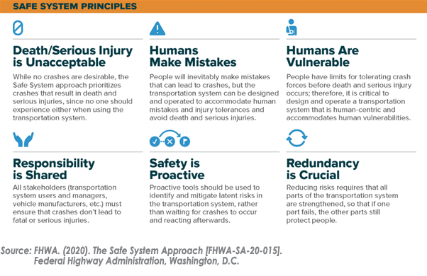
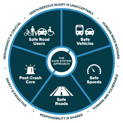
In developing Countywide Bikeway projects, designers should use Safe System principles and elements in determining bikeway type and design. Where bikeway facilities are routed parallel to the HIN, jurisdictions should consider corresponding safety projects such as road diets, traffic calming, or hot spot improvements to address the safety needs specific to the high-injury corridor. Resources from the Federal Highway Administration (FHWA) and consistent with the United States Department of Transportation (USDOT) National Roadway Safety Strategy should guide the selection of proven safety countermeasures on Countywide Bikeways that align with and are parallel to HINs. Adopting and communicating the Safe System approach for bicycle corridors supports multi-modal safety and accessibility and can help support policy-driven decision-making at the local level.
The FHWA has led nationally on developing guidance and resources on the Safe System Approach, including specific resources for pedestrian and bicycle planning and engineering. The FHWA website on Zero Deaths and Safe System includes a thorough resource library on safety, including a recently published Primer on Safe System Approach for Pedestrians and Bicyclists.

FHWA Primer on Safe System Approach for Pedestrians and Bicyclists
The Countywide Bikeways Network builds off the goals and priorities of the 2020 Countywide Transportation Plan (CTP), which recommends the Safe System Approach to reduce the number of severe and fatal transportation injuries, an approach consistent with the United States Department of Transportation and the Metropolitan Transportation Commission’s (MTC’s) goal of zero roadway fatalities. The FHWA has led nationally on developing guidance and resources on the Safe System Approach, including specific resources for pedestrian and bicycle planning and engineering. The FHWA website on Zero Deaths and Safe System includes a thorough resource library on safety, including a recently published Primer on Safe System Approach for Pedestrians and Bicyclists. The appendices of this primer include a useful benchmarking tool for jurisdictions to measure and track their processes on integrating the Safe System approach. Because local jurisdictions are now required to complete a LRSP, Vision Zero Action Plan, or similar Safe System planning document to be eligible for certain federal funding sources (e.g. Highway Safety Improvement Program (HSIP) and Safe Streets and Roads for All (SS4A) Grant Program), agencies within Alameda County should be well-prepared to implement projects along local and Countywide HIN using a data-driven approach to selecting safety countermeasures along with bikeway design.
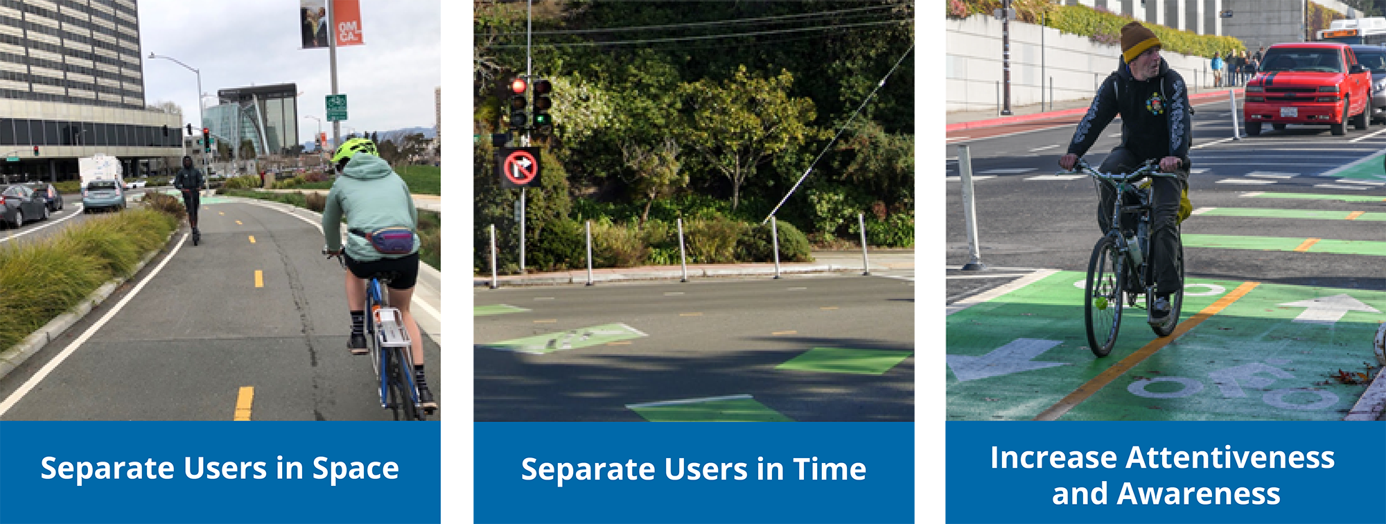
- Separating users in space: This approach segregates the physical space to provide travelers with a dedicated part of the right-of-way. Vulnerable and slower-moving bicyclists (and pedestrians) are separated in space to minimize conflicts with other users.
- Separating users in time: This approach assumes that users will need to occupy the same physical space on the roadway, but creates a safer environment by separating the users in time and reducing vehicle interactions with vulnerable road users. An example is a dedicated bike signal phase at an intersection with high conflicting turn movements.
- Increasing attentiveness and awareness: This approach seeks to alert users to potential hazards and/or the presence of other users. These techniques can be vehicle, user or infrastructure-based, such as:
- “Daylighting” intersections by removing parking at the corners to allow greater visibility between drivers and pedestrians.
- Street lighting that increases nighttime visibility of users.
- Green thermoplastic conflict markings at bicycle crossings, intersections, and driveways

Safe System
Improving the overall safety of the transportation system was a core need and priority coming out of the 2020 Countywide Transportation Plan (CTP). To this end, Alameda CTC is providing resources on safety best practices through trainings and information exchanges with members of ACTAC. This webpage includes resources on the Safe System Approach and Vision Zero implementation, including documents and video examples of implementation. This webpage will be updated as new resources become available. Click the blue bars below for resources.- Safe System Approach staff report
- Safe System Approach presentation and notes, assembled by Fehr & Peers for ACTAC
- May 2021 Video presentation of the Safe System Approach and information exchange/discussion (Part 1, Part 2, Part 3)
- Bikeway Selection Guide, Department of Transportation, Federal Highway Administration, February 2019
- NACTO Urban Design Guide
- NACTO Transit Urban Design Guide
- Multimodal Corridor Guidelines, AC Transit, April 2018
Vision Zero in Alameda County
- City of Berkeley Vision Zero Program
- City of Fremont Vision Zero Program
- City of Fremont Vision Zero Action Plan (May 2021)
Other Efforts in Alameda County
The City of Oakland has developed a Safe Oakland Streets (SOS) Initiative, with the purpose of preventing serious and fatal traffic crashes and eliminate crash inequities in the City. This site has many resources that provide crash data for Oakland and crash prevention design elements.- Safe Oakland Streets initiative
- Informational Report (Staff Report to City Council)
- Informational Report Appendix
- Efficacy and Equity Assessment
- March 2021 City Council presentation
- High Injury Network
- Geographic Equity Toolbox (includes an overlay with the HIN in the “safety map”)
- Citywide Crash Analysis
- Crash Prevention Street Design Toolkit
- School Traffic Safety
- Submit traffic safety request
Local Examples of Safety Projects
- City of Alameda
- Otis Drive Complete Street Project
- Central Avenue Safety Project
- City of Fremont
- Alameda County
- Alameda County Transportation Commission
How to use Roundabouts
- How to use a Roundabout, City of Burlingame, CA
- Modern Roundabouts, FHWA
- I-80/Gilman Interchange Roundabout Video Simulation, Alameda CTC
How to use Pedestrian Hybrid Beacons/HAWK Signals
Videos:- Pedestrian Hybrid Beacon/HAWK, City of Fremont, CA
- Pedestrian Hybrid Beacon/HAWK, Northeast Florida Department of Transportation
- Pedestrian Hybrid Beacon/HAWK, City of San Luis Obispo, CA
How to use Protected Intersections
Videos:- Walnut Avenue Bikeway and Protected Intersection, City of Fremont, CA
- Protected Intersection, The Angry Architect
How to use Different Bicycle Facilities
Videos:- Bicycle Safety Videos, City of Sacramento, CA
- Green Bike Lanes, City of Fremont, CA
- Sharrows, City of Fremont, CA


